Join
Join Donate
 Acadia National Park
Taken by Storm
Extreme weather is evident as the climate changes, and Acadia is faced with more questions than answers about whether to repair and rebuild – and if so, how.
March 8th, 2024
Extreme weather is evident as the climate changes, and Acadia is faced with more questions than answers about whether to repair and rebuild – and if so, how.
March 8th, 2024
By SHANNON BRYAN
EDITOR’S NOTE: As a complete assessment of the storm’s impact requires weeks of inspection and data gathering by park staff – some even needing to wait until spring for a full understanding – the damage noted here is what was known or understood to be true at the time.
For the most up-to-date information, check the park’s current conditions page.
Sand Beach temporarily disappeared under roiling Atlantic waters. Persistent winds buckled trees. Powerful waves pummeled the coastline, dismantling sections of Ocean Path. As the tide retreated, it left a mess of rocks and debris scattered across the Otter Cove causeway on the Park Loop Road and Seawall Picnic Area.
Back-to-back storms on January 10 and 13 wreaked havoc on the coast of Maine. In Acadia National Park, several locations experienced significant damage. While Maine is no stranger to winter storms (there have been four in the last two months), this duo packed an extraordinary punch.
“These were the most impactful storms on the coast since 1978,” said Rebecca Cole-Will, chief of resource management at Acadia National Park. “They’re probably more significant than that ’78 storm was because there’s so much more coastal infrastructure now than there was at that time.”
In more recent memory, a storm in June 2021 brought intense rainfall to Acadia, causing flooding and erosion to areas of the park, including extensive damage to 10 miles of carriage roads and the beloved Maple Spring Trail.
These January storms pounded the coast with intense winds and extremely high tides. And whereas Maine’s winter storms typically blow in from the northeast (commonly referred to as “nor’easters”), the January storms came from the southeast. On Isle au Haut, which hosts a section of Acadia, a 95-mile-per-hour wind gust was recorded, according to the National Weather Service.
These storms are the most recent examples of extreme weather events that are expected in greater frequency and intensity as the planet warms.
Sea level rise is another factor, making storm surges that much higher. The storm surge on January 10 raised the height of the sea four feet above the average high tide, or about the level predicted for sea level rise by the year 2100.
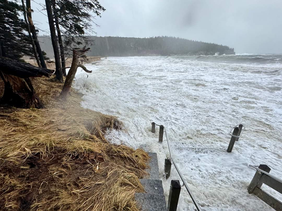
High tide inundates the Sand Beach staircase in Acadia National Park during a winter storm in January 2024. (Photo Courtesy Steve Boucher)
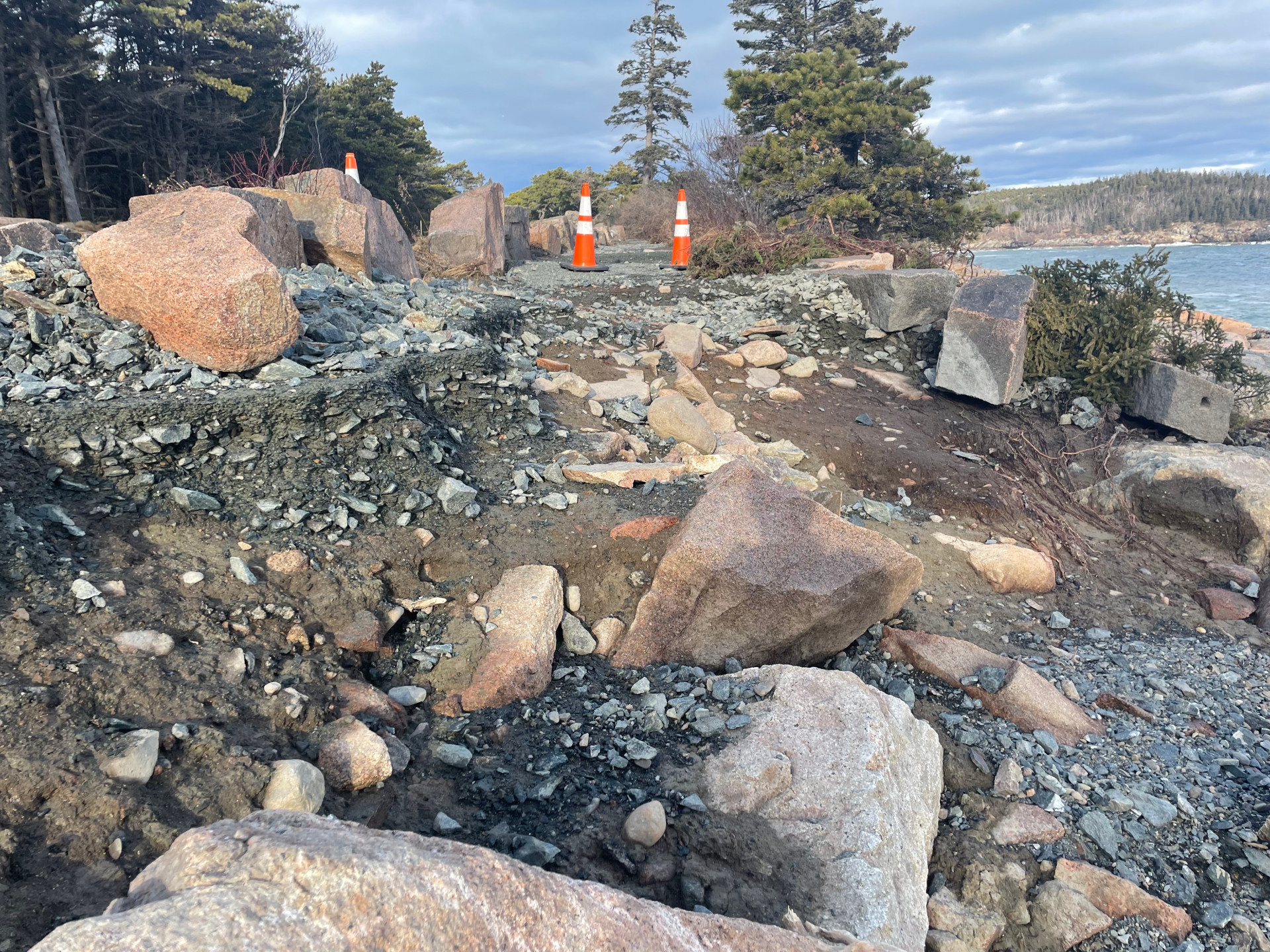
Among the early damage identified at Acadia are two sections of the popular Ocean Path. “The storm removed over 1,000 feet of trail. It’s just gone,” said Keith Johnston, chief of maintenance at Acadia National Park. “That’s also exposed the oceanside shoulder of the Park Loop Road; there will be significant stabilization efforts there to try to stop the road from getting worse over the coming weeks.”
The Schoodic Loop Road was also significantly undermined, he said, but more exploration is needed to understand the extent of damage.
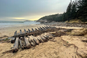
Another big hit was felt at Seawall Campground and Picnic Area. “The Seawall Picnic Area is by far the most eye-opening place I have seen where the seawall was pushed inland,” Keith said. Down the road, Ship Harbor Trail lost a lot of bog walk from out on the point, where the vigorous wave action broke it apart. “I found bog walk from the Ship Harbor Trail in the Seawall Picnic Area,” Keith said. “So that went out to sea around Wonderland and back onto the beach at Seawall Picnic Area.”
On the park portion of Little Cranberry Island, siding came off the Blue Duck—a former ship’s chandlery built in 1853 that currently serves as home to Islesford Boatworks—and there’s a hole in the building’s foundation.
The Otter Cove causeway has likely suffered structural damage, and the water line along the causeway was fully exposed and may also be damaged. “That’s all tangled up in ocean debris,” said Keith. “We won’t know if that water line is viable until we pressurize it, which we can’t do until winter’s near over.”
> See photos from the storm’s aftermath
Park crews were out immediately following the storms to begin surveying and tracking the impact. In fact, they were out right after the winds calmed on January 10, and their efforts to shore up some areas likely prevented additional damage from the second storm a few days later.
Straight away, Keith said, crews were in the park assessing the damage and stabilizing the unstable. “You have to prioritize. What are you going to fix first? What’s most important? What has critical life, health, safety issues?”
But understanding the full breadth of the storms’ impacts will take time.
Erosion and other washout damage to Ocean Path after a winter storm in January 2024. (NPS photo)
“It’ll be weeks in terms of gathering all the data we need and then formalizing the plan for developing cost estimates, developing the GIS data and mapping data to show where the damage is, the quantity of damage, and materials costs,” Keith said. In some places, snow cover inhibits crews from seeing the scope of impact, so the true extent of damage won’t be completely understood until spring.
Following the assessment, Keith said, the park will connect with the regional and Washington offices of the National Park Service to devise a plan for addressing the damage. That may include assistance from trail crews from other national parks or outside incident management teams. There is also separate potential funding for federal roads. Those plans will begin to take shape in the months ahead.
> Check current conditions on Acadia National Park’s website
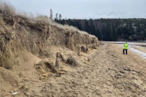
A section of damaged road at Seawall in Bass Harbor following a destructive winter storm on January 14, 2024. Photo by Julia Walker Thomas/Friends of Acadia
The storm surge on January 10 raised the height of the sea four feet above the average high tide, or about the level predicted for sea level rise by the year 2100. Suddenly, it seems, the future is here.
Read MoreHow does the park repair or rebuild in preparation for the unknown?
“We are having challenges predicting what the future climate scenarios are going to look like for wind, waves, rain, snow,” said Keith. “Our weather forecasters are challenged with this, too. We just have to roll with it and try to make smart decisions.”
Those smart decisions are born out of a framework Acadia uses known as Resist-Accept-Direct (RAD). This framework is designed to help resource managers consider different options in the face of a changing climate. Where does it make sense to “hold the line” and try to prevent change from happening? Where is it wise to accept those changes and let nature take its course? And where do they want to encourage things in a new direction?
“That’s a lot of what our work entails trying to figure out what to do with limited park resources given these kinds of impacts going forward,” said Rebecca. “The response isn’t just one thing. We’re thinking across a really broad spectrum of potential responses, and that’s where the RAD approach is most useful.”
“Thunder Hole used to have a really nice granite facade on the exterior and every time a tiny storm hit, it’d knock all the granite off,” Keith said. “We found ourselves constantly patching masonry to keep that granite aesthetic. In the long run, we ended up removing all the aesthetic stones but putting reinforced concrete that’s tinted pink to match the landscape in its place. And we haven’t had to go back and repair that since.”
The January storms were much bigger, and the waves reached further onshore and undermined the top portion of the walkway at Thunder Hole. But areas with the modified concrete held up—an example of accepting change while improving resilience.
“The rebuild is gesturing to the recognition that this area has changed,” said Rebecca. “It’s not like we’re going to resist the change and make it look just the way it did in 1916. As we make decisions around rebuilding and rehabbing, there are also opportunities to consider whether there is something else we can do here that will also create a little more resiliency the next time.”
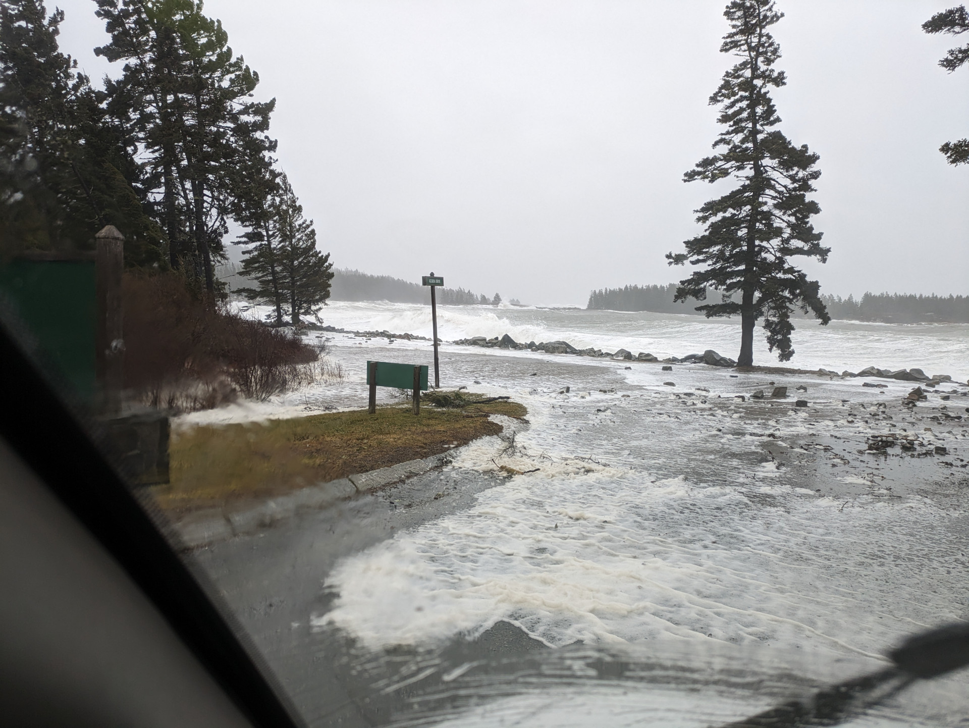
Waves crash over the road at the entrance to the Schoodic Institute in Winter Harbor during a destructive winter storm in January 2024. (Photo by Craig Pinkham/Schoodic Institute)
This approach is not necessarily new.
Friends of Acadia has partnered with the park and Schoodic Institute for more than a decade to help park ecosystems be resilient to the anticipated changes.
Thoughtful science, forward-thinking management, organizational collaboration, and strategic investments at Cadillac Mountain, Great Meadow Wetland, and Bass Harbor Marsh have positioned Acadia as a leader in climate-smart restoration. And with funding from the Bipartisan Infrastructure Law last year, the work was scaled up for even greater impact.
“Dramatic weather events like those we have experienced this winter create great anxiety and sadness as we witness the damage and understand that we are vulnerable to nature’s fury,” said Stephanie Clement Friends of Acadia’s vice president of conservation. “Acadia’s use of the RAD approach restores a semblance of control—that we can observe the changes happening here and work together toward desired future conditions.”
“The way I look at it, the park’s going to be here in 100 years, in 200 years, in 500 years,” said John Kelly, management assistant at Acadia National Park. We don’t know what specific elements will be present, or what shape they’ll take. But if we continue to care for the park, it will be here.”
Collaborative and science-forward initiatives help park ecosystems be resilient to the changes happening within and around them.
Learn More